Marne Green Space

20180604_140912

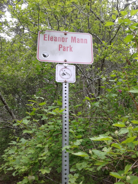
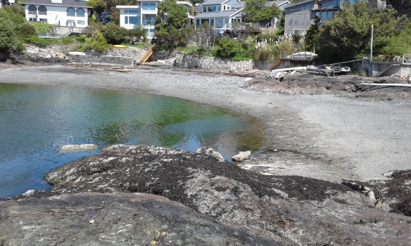
Marne Green Space is in the seaside community of Oak Bay, one of thirteen communities that form the Capital Regional District of British Columbia. Located close to the Chinese Cemetery and Trafalger Park, Marne Green Space provides access to Gonzales Beach along its eastern shore. The beach access is rough and the beach in this area is mostly bedrocks covered in seaweeds. The name for the street has historical relevance. Marne, a department and river that lies to the east of Paris, France, was a significant battle during first world war that was victory for the Allies. Quimper Park, Repulse Green Space, the Abkhazi Gardens, Gonzales Hill Regional Park, Harling Point Green Space, Trafalger Park and Gonzales Beach Park, in Victoria, are nearby.

Geographic Location N48º 24’ 29”  W123º 19’ 20”

Marne Green Space can be reached from the Trans-Canada Highway. Continue along the Hwy 1 into Victoria as it becomes Douglas Street. Turn off Douglas onto Hillside Avenue to head east. Stay on Hillside Avenue as it becomes Lansdowne Road. Continue along Lansdowne Road to reach Foul Bay Road. Turn right onto Foul Bay Road and continue along Foul Bay Road to reach King George Terrace. Make a left turn then immediately turn right onto Crescent Road and follow to Repulse Street. Turn onto Repulse Street then make a right turn onto Marne Street. The green space is at the end of the road.  There is limited street parking in this residential neighborhood.  City buses travel close to this park.

Oak Bay High School Green Space

Oak Bay High School Green Space is in the seaside community of Oak Bay, one of thirteen areas of the Capital Regional District of British Columbia. This green space is has several pedestrian friendly pathways and large sports fields including an artificial turf field. This field is fenced with chain-linked wire fencing. There is a concrete seating area on the northside of the field. There several grass covered areas around the green space including the center of the oval running track. A large garry oak tree provides invaluable shade at the track. The school is part of the British Columbia School District  61 Victoria and the green space is accessible outside of school hours until dark. The school was rebuilt in 2016; the original buildings were from the late nineteen twenties. A large giant sequoia tree was planted in eighteen sixty two by Mr Alexis Casanave whose had property bordered along Bowker Creek.  Several Garry oak trees are found on this green space. Bowker Creek Park borders on the south side while the Oak Bay Recreation Center lies to the southeast.

Geographic Location N48º 25’ 58”  W123º 19’ 5”

Oak Bay High School Green Space can be reached from the Trans Canada Highway. Continue along the Hwy 1 into Victoria as it becomes Douglas Street. Turn off Douglas onto Hillside Avenue to head east. Stay on Hillside Avenue as it becomes Lansdowne Road. Continue along Lansdowne Road to reach Foul Bay Road. Turn onto Cadboro Bay Road to head east and look for the green space and parking area on the right. There are several parking areas and some street parking along Canmore Street. City buses travel along Cadboro Bay Road and Foul Bay Road.


Eleanor Mann Park

Eleanor Mann Park sign

Eleanor Mann Park is in the District of Metchosin, a coastal community in the Capital Regional District of British Columbia.   This forested area was selectively logged in the mid nineteen hundreds and continues to support cedar, Douglas fir and arbutus trees. Salal, ferns, mosses and lichen form part of the understory. The Mann family business, Don Mann Excavating Ltd, donated the parkland in the memory of Eleanor, wife of Don and mother to Steve, current proprietor of the family business. The main trails are bridle trails that are interconnected to the pathways from the end of Sweet Chestnut Place, along Liberty Drive and near the end of Arden Road.   Metchosin Wilderness Park, Bob Mountain Park and Buckbrush Swamp Park are nearby.

Geographical location N48º 22’23” W123º 34’ 48”

Eleanor Mann Park can be reached from the TransCanada Highway (Hwy 1) when you exit at the Millstream /Veteran Memorial Parkway exit. Head south along the Veteran Memorial Parkway to reach Latoria Road. Turn right onto Latoria Road and continue along to reach Happy Valley Road. Turn left onto Happy Valley Road then right onto Rocky Point Road. Continue along Rocky Point Road to reach Liberty Drive. Follow along Liberty Drive to reach Deer Park Trail and look for the park access at the end of the road.

Bob Mountain Park


Bob Mountain Park is in the District of Metchosin, a coastal community in the Capital Regional District of British Columbia. This park is a long narrow area that includes a steep sloped section that leads down toward the Matheson Lake Regional Park and the Galloping Goose Trail. Selectively logged in the early nine hundreds, the forest is composed of cedars, Douglas fir and ferns.  Grasses, mosses and smaller plants cover areas around exposed rock. This five hundred and sixteen meter long forest trail drops about 40 meters down along its path toward Matheson Lake Regional Park. Bob Mountain Park is about twenty meters wide along most of its length. Its rough trail is bordered by the homesteads on both sides.  The trailhead is along Liberty Drive near Metchosin Wilderness Park and Buckbush Swamp Park. The upper section is well trodden by dog walkers, hikers and mountain bikers. There is no hilltop in this park called Bob Mountain yet there is a one hundred and forty meter high peak within the parkland that appears unnamed on most maps. Matheson Lake Regional Park, the Galloping Goose Trail – Metchosin, Buckbrush Swamp Park, Metchosin Wilderness Park and Montreal Hill Park are nearby.

Geographical location N48º 21’ 58” W123º 34’ 53”

Bob Mountain Park can be reached from the TransCanada Highway (Hwy 1) when you exit at the Millstream /Veteran Memorial Parkway exit. Head south along the Veteran Memorial Parkway to reach Latoria Road. Turn right onto Latoria Road and continue along to reach Happy Valley Road. Turn left onto Happy Valley Road and then right onto Rocky Point Road. Continue along Rocky Point Road to reach Liberty Drive. Turn right onto Liberty Drive and follow along the curves in the road to reach Woodley Ghyll Drive. Turn left onto Woodley Ghyll Drive and look for the trail marker at the intersection. There is a partially covered shelter on this corner with limited roadside parking. City buses travel along Happy Valley Road and Rocky Point Road.

Spellman Park


Spellman Park is in the District of Metchosin, a coastal community in the Capital Regional District of British Columbia. This steep sloped nature park is a Douglas fir and cedar forested area amongst private properties. There are no formal trails into this parkland. Blinkhorn Park and Carlton Cosh Park are nearby.

Geographical location  N48º 23’ 28” W123º 34’ 35”

Spellman Park can be reached from Highway 1 when you exit at the Millstream /Veteran Memorial Parkway exit. Head south along the Veteran Memorial Parkway to reach Sooke Road. Turn left onto Sooke Road and continue along to reach Kangaroo Road. Turn right onto Kangaroo Road and then left onto Lindholm Road. The park is on the corner of Spellman Place and Lindholm Road. Access to Blinkhorn Park is across the Road. There is limited road side parking.  City buses travel along Metchosin Road.

Madrill Green Space

The Madrill family of My Chosen Café, Pizza, Sugar Shack and the Critter Corner provided the name for this connector trail. Madrill Green Space is in Metchosin, B.C., a coastal community in the Greater Victoria Regional Area. The green space is a two hundred and thirty meter connector trail from the cricket pitch near Happy Valley Road to along William Head Road. The trail is a rough grassy covered trail with a slight slope to William Head Road. The green space is bordered by cedar hedge trees and a wire and wooden fence along a grass field. This is a terrific place to stretch your legs after enjoying a snack or meal at My Chosen Café venues or after watching a cricket game, horse event or other community events hosted by the District of Metchosin. The Cricket Park, Bike Park, Metchosin Riding Ring and museum are nearby. Hillman Green Space, Sea Bluff Park and St Mary’s Green Space are also nearby.

Geographical Location N48º 22’ 40” W123º 31’ 56”

Madrill Green Space can be reached from Highway 1 when you exit at the Millstream /Veteran Memorial Parkway exit. Head south along the Veteran Memorial Parkway to reach Latoria Road. Turn right onto Latoria Road and continue along to reach Happy Valley Road. Turn left onto Happy Valley Road. Continue along Happy Valley Road and look for the school building on the left. There is a small parking area. City buses travel along Happy Valley Road toward Metchosin Road.

Seaspray Park

Seaspray Park is in the District of Metchosin, a coastal community in the Capital Regional District of British Columbia. At two tenths of a hectare, this nature park is nestled in between two acreages in the Albert Head/Duke Point neighborhood. There is little to indicate that this park is a community area except for a small gravel parking area on the side of the turnabout at the end Seapsray Drive. Cedar and fir trees compose most of the canopy trees with a few big leaf maple trees. The undergrowth includes salal, broom and ferns. This can be a peaceful place to visit.

Geographical Location N48º 23’ 43” W123º 30’ 2”

Seaspray Park can be reached from the TransCanada Highway (Hwy 1). Exit the highway onto the Old Island Highway into Colwood. Follow the Old Island Highway as it becomes Sooke Road. Turn left onto Metchosin Road and continue along Metchosin Road to reach Chapel Heights Road. Turn left onto Chapel Heights Road then right onto Seaspray Road. Continue to the end of the street and look for the park between homes 384 and 389. City buses travel along Metchosin Road.

Desmond North Park

Desmond North Park is in the Triangle Mountain and Braemar neighborhood of Langford, B.C. This half a hectare polygon shaped green space is on the western slope of Triangular Hill also called Triangle Mountain. Rocky outcrops with cedar and Douglas fir trees are seen in this area of Southern Vancouver Island. The nature park has a gravel foot path the parallels Desmond Drive before curving eastward to connect with Kelly Dawn Place.  The trail branches to reach Desmond Drive between homes 3562 and 3554. Havenwood Park, in Colwood, Sunhills Park, Sun Estates Park, Desmond South Park, Desmond North Park and Ernhill Park are nearby.


Geographic location N48° 24’50”  W123°30’48”


Desmond North Park can be reached from the Trans Canada Highway also called Hwy1. Turn at Millstream exit and continue along south to reach the Veterans Memorial Parkway. Continue along VMP to reach Latoria Road. Follow Latoria Road to the right to reach Desmond Road. The foot path can be seen on the right near the junction of Desmond Road and Latoria Road. There is limited roadside parking in this area. Alternatively turn onto Kelly Dawn Place and look for the gravel and grass trail between homes 3570 and 3566. City buses travel along Latoria Road.


A.T. Gordon Memorial Park

A.T. Gordon Memorial Park is in the Happy Valley neighborhood of Langford, B.C. This park is the legacy of volunteer firefighter and gentle man who resided  in Langford: Mister Alexander Thomas Gordon. The park has baseball diamond with chain link fencing, a seasonal concession, picnic tables and washrooms. There is also a playground and walking trail along Nisbit Creek. The playground has some climbing apparatus, monkey bars and swings set on a wood chip base. The three hundred meter long walking trail is past the park toward the northeast corner. A few urban trees have been planted in this park including maple and oak. The wind row on the west side has blackberry bushes while the foot path is bordered by alder and cottonwood trees. There are some seasonal wetlands along the footpath and are protected by a short boardwalk and bridge. This park is labeled Valley View Park on some maps. The Galloping Goose Trail – Langford borders on this park.  Willing Park, Wild Ridge Park, Vitality Park, Linda Loma Park and the Southern Vancouver Island Rangers Green Space are nearby.


Geographic location N48° 24’34”  W123°32’18”


A.T. Gordon Memorial Park can be reached from the Trans Canada Highway also called Hwy1. Turn at Millstream exit and continue south to reach Veteran’s Memorial Parkway. Continue on the Parkway to reach Latoria Road. Turn right onto Latoria Road and continue to Happy Valley Road. Turn left onto Happy Valley Road and turn left onto Wild Ridge Way. AT Gordon Memorial P and baseball diamond are on the left where there is small parking area. City buses travel along Happy Valley Road.

Chan Streamside Park

Chan Streamside Park is in the Mill Hill neighborhood of Langford, B.C. This nature park borders along Mill Stream, or Millstream Creek, near Mill Hill Regional Park. There is access from along Atkins Road near the Selica Road junction. As a nature park, there are no formal trails yet the area has several deer trails though the second growth forest of western red cedar, big leaf maple and Douglas fir. Indian plum, pacific ninebark, oregon beaked moss, St John’s wort and the tricolor turkey tail mushrooms grow on the slopes of the ravine that forms this parkland. The Galloping Goose Trail, Trans Canada Trail, Westwind Park, Millstream South Park, Atkins Park, Millstream Creek Park One, Mill Hill Regional Park, Selica Park and Tanzanite Park are nearby.

Geographic location N48° 26’ 59” W123° 28’ 42”

Chan Streamside Park can be reached from the Trans Canada Highway also called Hwy1. Turn at Millstream Road and turn south onto Veterans Memorial Parkway. Turn left onto Hoffman Avenue then right onto Winster Road and left onto Atkins Road. The park is on the left side of Atkins Road between homes 417 and 409. There is limited roadside parking along Atkins Road. City buses travel along the road.