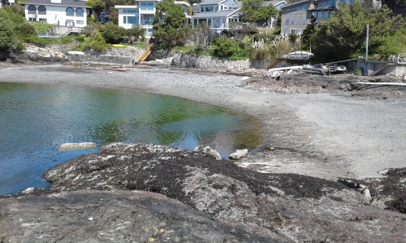
Marne Green Space

20180604_140912

Marne Green Space is in the seaside community of Oak Bay, one of thirteen communities that form the Capital Regional District of British Columbia. Located close to the Chinese Cemetery and Trafalger Park, Marne Green Space provides access to Gonzales Beach along its eastern shore. The beach access is rough and the beach in this area is mostly bedrocks covered in seaweeds. The name for the street has historical relevance. Marne, a department and river that lies to the east of Paris, France, was a significant battle during first world war that was victory for the Allies. Quimper Park, Repulse Green Space, the Abkhazi Gardens, Gonzales Hill Regional Park, Harling Point Green Space, Trafalger Park and Gonzales Beach Park, in Victoria, are nearby.

Geographic Location N48º 24’ 29”  W123º 19’ 20”

Marne Green Space can be reached from the Trans-Canada Highway. Continue along the Hwy 1 into Victoria as it becomes Douglas Street. Turn off Douglas onto Hillside Avenue to head east. Stay on Hillside Avenue as it becomes Lansdowne Road. Continue along Lansdowne Road to reach Foul Bay Road. Turn right onto Foul Bay Road and continue along Foul Bay Road to reach King George Terrace. Make a left turn then immediately turn right onto Crescent Road and follow to Repulse Street. Turn onto Repulse Street then make a right turn onto Marne Street. The green space is at the end of the road.  There is limited street parking in this residential neighborhood.  City buses travel close to this park.

Gonzales Bay Park

Gonzales Bay Park, or more commonly called Gonzales Beach, is a very popular water front park with a sandy beach. It is also known as Foul Bay. This wonderful beach is best at low tides. The western end is the main access where there are toilets, picnic tables and several benches. The beach access is steep but wheel chair accessible. At each curve in the pathway to the beach is a terrace with some grass and a picnic table. This is a great place to lounge on the beach or the grassy terraces that overlook the beach but arrive early as this is a popular place. There are excellent views of Gonzales Bay, Trial Island and lighthouse, the Strait of Juan de Fuca and toward the Olympic Mountains of Washington State, USA. There is a beach access from both Foul Bay and Crescent roads via staircases which end near the eastern end of the beach. Fairfield Hill Park, Ross Bay Cemetery, Clover Point are nearby. Gonzales Regional Park with the observatory is on the hilltop about five blocks away.

Geographic coordinates N48° 24′ 42” W123° 19′ 49″

Gonzales Bay Park can be reached from Blanchard Street. Turn east onto Fairfield Road and follow along to Foul Bay Road. Turn right onto Foul Bay Road then right again onto Crescent Road. Look for the park located on at the junction with Ross Street. There is limited roadside parking along Foul Bay and Crescent Roads and small parking area at the end of Ross Street. City buses travel along Fairfield Road from downtown Victoria.

Crescent Road Green Space

Stunning water views are seen from this linear green space. It hosts a pathway beside a large arbutus and a couple of Douglas fir trees. The pathway is a wide slope concrete sidewalk to a concrete fifteen step staircase that leads to the sandy shores of Gonzales Beach. Foul Bay Road Green space is a couple of houses to the east and Gonzales Beach can also be accessed from Ross Street a few houses west along Crescent Road.

Geographic coordinates N48° 24′ 43” W123° 19′ 41″

Crescent Road Green Space can be reached from Blanchard Street. Turn east onto Fairfield Road and follow along to Foul Bay Road. Turn right onto Foul Bay and then right onto Crescent Road. The green space is at 1849 Crescent Road where there is limited roadside parking along. City buses travel along Fairfield Road from downtown.

Foul Bay Road Green Space

The southern end of Foul Bay Road, Victoria, BC, ends at Gonzales Bay which is part of the Salish Sea in British Columbia, Canada. This bay was once called Foul Bay, which was a misspelling of the word fowl: as the area once was a fowl farm established by landowner Isabelle Ross and her family. This green space hosts a concrete pathway beside a large Garry oak tree. The pathway leads to long concrete staircase that ends in the rocky area of the eastern side of Gonzales Beach. Gonzales Hill Regional Park is on the hilltop north of this green space. Crescent Road Green Space is about four houses west along Crescent Road. Harling Point Cemetery Green Space is to the east.

Geographic coordinates N48° 24′ 42” W123° 19′ 36″

Foul Bay Road Green Space can be reached from Blanchard Street. Turn east onto Fairfield Road and follow along to Foul Bay Road. Turn right onto Foul Bay Road and continue across Crescent Road. There is limited roadside parking along Foul Bay and Crescent Road access. City buses travel along Fairfield Road from downtown.