Trans Canada Highway Pedestrian Green Space

Florence Lake Stachen Trail 12 Florence Lake Stachen Trail 11

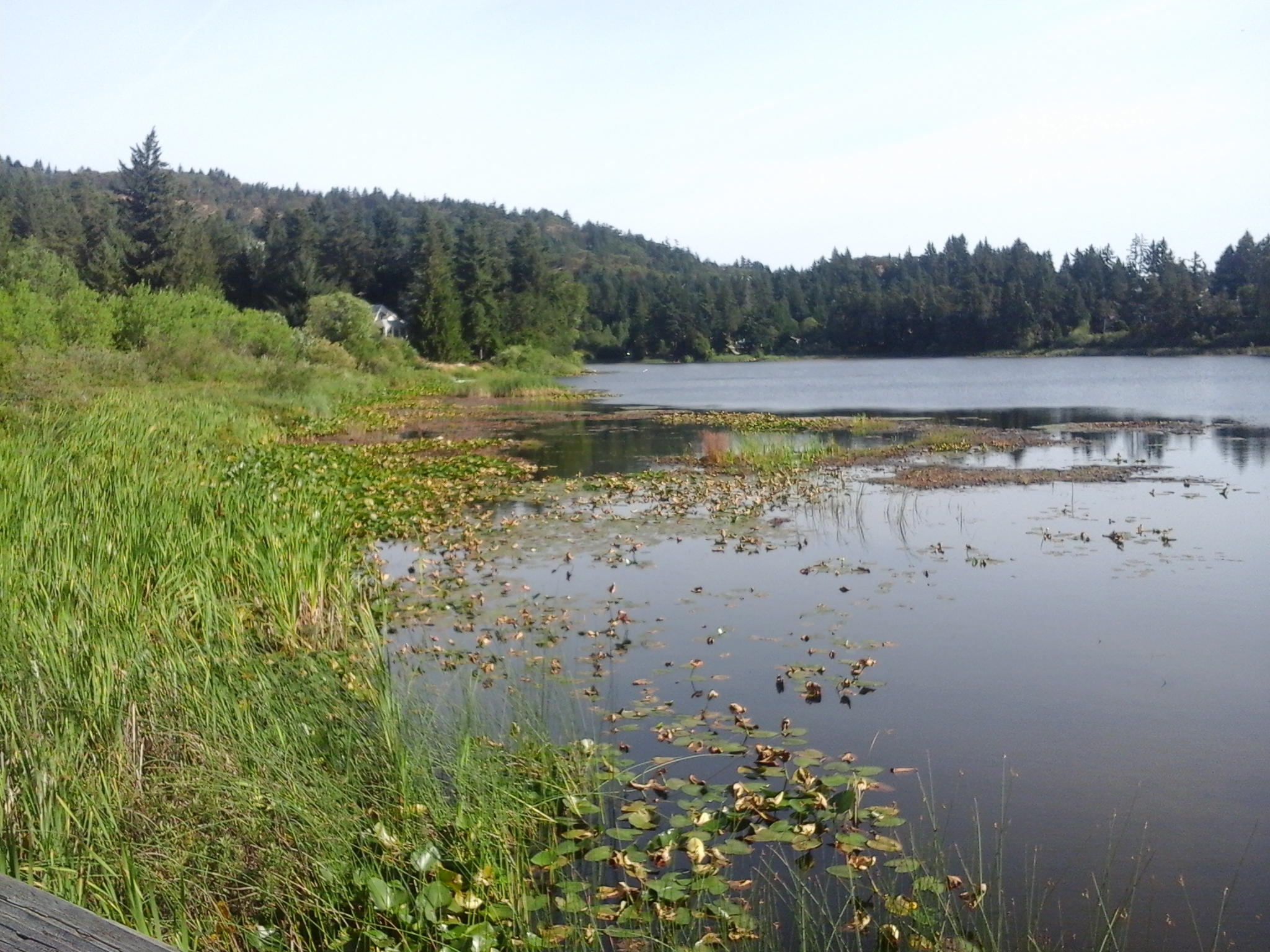
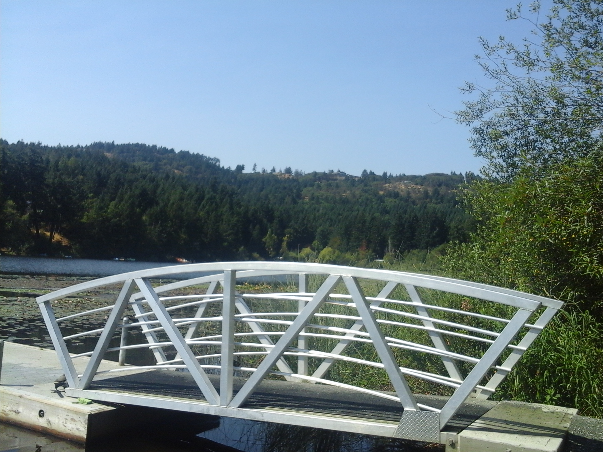
The two kilometer pedestrian walkway along McCallum and Leigh roads, south of Florence Lake, connects the north and south neighborhoods of Langford, B.C. The Trans Canada Highway Pedestrian Green Space was formed with the road construction for the Bear Mountain housing projects that created a bridge for pedestrians and vehicles over the highway. The walkway is along a concrete sidewalk that parallels the roadways. A tall barrier fence thwarts humans from crossing the highway at the original intersection for Spencer Road. The green space that parallels McCallum Road to the junction with Leigh Road has several tall Douglas fir trees in the forest areas while boulevard was planted with maple and horsechestnut trees. The pathway continues over the TCH along Leigh Road, past Spencer’s Pond Park, to reach Goldstream Avenue. The route can reached from Springboard Place and the Florence Lake Strachan Trail.

Geographic location N48° 27’21” W123°30’56” at Savory Road junction

Trans Canada Highway Pedestrian Green Space can be reached from the Trans Canada Highway also called Hwy1. Turn at McCallum/Savory Road/Brock Road Exit (#15) and follow the road to turn west then north onto McCallum Road. The Shell Service Station is at this junction besides a Subway and office building. The road curves around a wetland area of Florence Lake and head up a slight slope to reach the junction with Savory Road. Turn right onto Savory Road where there is limited roadside parking this area. The pedestrian pathway parallels McCallum Road.

Savory Park

Florence Lake Stachen Trail 7

Savory Park is a nature park in the Florence Lake neighborhood of Langford, B.C. The half hectare parkland borders along the Springboard section of the Florence Lake Strachan Trail, a one and half kilometer long boardwalk and gravel footpath along the south and eastern shore. Savory Park slopes down to the lake from Savory Road and is covered with dense thickets of shoreline vegetation including cattails, alder, willows and ocean spray. Wetlands of Florence Lake form much of the nature area of the park. This park is close to the Trans Canada Highway Pedestrian pathway, a concrete pathway along the roadway that leads southward over the TCH toward Langford Lake.

Geographic location N48° 28’5” W123°30’41”

Savory Park can be reached from the Trans Canada Highway also called Hwy1. Turn at Savory Road/Brock Road Exit and follow the road to curve westward onto McCallum Road. Turn right onto Savory Road and look for the trail marker for the Florence Lake Strachan Trail. This park is to the left of the trail. There is limited roadside parking this area.

Citation Green Space

Citation GS 1

Citation Green Space is along the gated paved section of Citation Road in Langford, B.C. The seventy meter long pathway is frequented by dog walking, hikers and walkers as it connects with McCallum Road. Blackberries are found along the border of this green space which also has a small Douglas fir tree forest to the south. There are arbutus trees, ocean spray and snow berry shrubs found near this green space. Cavalcade Green Space, Cavalcade Park and Florence Lake – Strachan Trail are nearby.

Geographic location N48° 27’23” W123°30’23”

Citation Green Space can be reached from the Trans Canada Highway also called Hwy1. Turn at Savory Road/Brock Road Exit and follow the road to curve eastward around Florence lake. Turn right onto Citation Road and look for the fire road at the junction with Secretariat Way. There is limited roadside parking this area.

Florence Lake Strachan Trail

Florence Lake Strachan Trail gravel Florence Lake Strachan Trail pier

Florence Lake Strachan Trail is an one and half kilometer trail that follows the eastern shore of Florence Lake in Langford, B.C. Florence Lake is a shallow glacial kettle lake that lies on the slopes of Skirt Mountain. There are several view points from along the boardwalk. This section is shades by some large western red cedar and Douglas fir trees. The board walk becomes to a gravel trail and there are a few places to access the water for swimming and wading. The boat launch, for small personal watercraft like kayaks, paddle boards and canoes, has a pier beside it. It is a short stroll from the main trail. There are several benches along the route for rest stops.The gravel pathway traverses through the wetlands on the southeastern end of the lake. Alder dominate the shrubs in this area. A board walk connects the gravel trail to Savory Road along the southwestern side of the lake. The trail parallels Florence Lake Road, Brock Avenue and Springboard Road. The north end of the trail is at (geographic location and the southern end of the trail is at Savory Park.

Geographic location for Florence Lake Park North N48° 27’41” W123°30’45”

Florence Lake Strachan Trail can be reached from the Trans Canada Highway also called Hwy1. Turn at McCallum Road/Spencer Road exit and continue along McCallum Road to reach Brock and Springboard roads. Follow the curve to the right to stay on McCallum Road and then take the curve to the left to turn onto Florence Lake Road. Stay on Florence Lake Road and look for a small parking area, on the left, past the junction with Setchfield Avenue. There is three parking sites at this park and limited roadside parking. City buses travel along Setchfield Avenue.

Strachan Park

Strachan Park is a nature park in the Florence Lake neighborhood of Langford, B.C. At just over half a hectare, the steep terrain that surrounds the small wetland in this park has helped to maintain its natural integrity. Florence Lake Pier and Viewing Dock, Florence Lake Park North, Florence Lake Strachan Trail Shaw Green Space and Shaw Park are nearby.

Geographic location N48° 27’37” W123°30’36”

Strachan Park can be reached from the Trans Canada Highway also called Hwy1. Turn at Savory Road/Brock Road Exit and follow the road to curve eastward around Florence Lake. Turn right onto Setchfield Avenue then right onto a roadway called Martin Ridge. The park is on the right. There is limited roadside parking this area.

Florence Lake Pier

The pier and viewing dock at Florence Lake is a great place to explore nature and the outdoors. This park is found in the Florence Lake neighborhood of Langford, B.C. The pier and view dock are used by fishers and swimmers who enjoy the warm waters of this shallow lake. A small boat launch area is found beside the dock that is used by kayakers, paddle boarders and canoeists. Florence Lake is a shallow glacial kettle lake with a surface area of about eight hectares and average depth about two meters. There is one seasonal tributary, Florence Lake Creek North, providing water flow into the lake from the slopes of Skirt Mountain which lies to the northwest. Florence Lake Creek South drains from the south end of the lake and flows through a series of culverts, mostly under the Trans Canada Highway, until it reaches Mill Stream. The lake had been stocked with rainbow trout for several decades until the water quality was determined to limit fish survival. Florence Lake Park North is a couple of hundred meters north while Strachan Trail is the pathway along the shore. Strachan Trail lies along the eastern shore of Florence Lake and is about a three kilometer return stroll over flat terrain.

Geographic location N48° 27’30” W123°30’39”

Florence Lake Pier and Viewing Dock can be reached from the Trans Canada Highway also called Hwy1. Turn at McCallum Road/Spencer Road exit and continue along McCallum Road to reach Florence Lake Road. Stay on Florence Lake Road and look for a small parking area just past the junction with Shaw Avenue. There is three parking sites at this park and limited roadside parking and it is short stroll to the viewing dock and pier.

Florence Lake Park North

Florence Lake North Florence Lake North view

A sixty meter long boardwalk is the focal point for Florence Lake Park North. This park is found in the Florence Lake neighborhood of Langford, B.C. Florence Lake is a shallow glacial kettle lake with a surface area of about eight hectares and average depth about two meters. There is one seasonal tributary, Florence Lake Creek North, providing water flow into the lake from the slopes of Skirt Mountain which lies to the northwest. Florence Lake Creek South drains from the south end of the lake and flows through a series of culverts, mostly under the Trans Canada Highway, until it reaches Mill Stream. The lake had been stocked with rainbow trout for several decades until the water quality was determined to limit fish survival. This park is marks the north eastern end of the walk along the shore of Florence Lake. Strachan Trail, along Florence Lake, is about a three kilometer return stroll over flat terrain. This is good place to enjoy the views the water fowl and flora on Southern Vancouver Island, B.C.

Geographic location N48° 27’41” W123°30’45”

Florence Lake Park North can be reached from the Trans Canada Highway also called Hwy1. Turn at McCallum Road/Spencer Road exit and continue along McCallum Road to reach Brock and Springboard roads. Follow the curve to the right to stay on McCallum Road and then take the curve to the left to turn onto Florence Lake Road. Stay on Florence Lake Road and look for a small parking area, on the left, past the junction with Setchfield Avenue. There are three parking sites at this park. City buses travel along Setchfield Avenue.

Shaw Green Space

Shaw GS from gade

Shaw Green Space is in the Florence Lake neighborhood of Langford, B.C. This green space is formed from the gravel fire road that connects Shaw Avenue to Florence Lake Road. This ninety meter long pathway is gated at both ends and is near Shaw and Ironwood parks as well as the trail along Florence Lake. There are limited views of Florence Lake from this green space. This route is frequented by dog walkers, hikers and walkers.

Geographic location N48° 27’49” W123°30’35”

Shaw Green Space can be reached from the Trans Canada Highway also called Hwy1. Turn at Millstream Road and turn left at the log house pub onto Treanor Avenue. Continue along Treanor to reach Setchfield Avenue. Turn right onto Setchfield Avenue then take the first left onto Shaw Avenue. The park is near the junction of Shaw Avenue with Buckler Avenue. There is limited roadside parking this area.

Setchfield Shaw Green Space

Setchfield Shaw GS 3

Setchfield Shaw Green Space is in the Florence Lake neighborhood of Langford, B.C. There is a seventy five meter long gravel pathway that connects Setchfield Avenue up to Shaw Avenue. This pathway is bordered by wood and rock fences of the neighboring properties and a few blackberry bushes as it zigzags up the slope. A few trees are found along this trail that is frequented by dog walkers, hikers and walkers. The exposed bedrock is mostly granite which has been altered to form small pocket for plants near the house at 955 Shaw Avenue. Shaw and Ironwood Park are to the west across Shaw Road where as Lakewood Elementary School Green Space, Camli Green Space, Setchfield Park and Lake Ida Ann Park are to the east from Setchfield Avenue.

Geographic location N48° 27’58” W123°30’30”

Setchfield Shaw Green Space can be reached from the Trans Canada Highway also called Hwy1. Turn at Millstream Road and turn left onto Treanor Avenue. Continue along Treanor to reach Setchfield Avenue. Turn left and look for the gravel trail on the right between 2342 and 2350. The trail leads to the driveway at 955 Shaw Avenue and onto the street. There is roadside parking along Setchfield Avenue near Lakewood Elementary School Green Space. City buses travel along Treanor and Setchfield avenues.

Lakewood Elementary School Green Space

Lakewood Elementary School GS 7Lakewood Elementary School GS 4

Lakewood Elementary School is part the Sooke School District (number sixty two). The green space includes the large school yard with two large sports fields and several playground areas. The two hectare green space is in the Florence Lake neighborhood of Langford, B.C. The south playground is on a wood chip base with a curved slide with step ladder access and a separate climbing bar set. A few meters up the slope are six swings that are on a wood chip base. Further along the south side of the school grounds is a climbable rope web with an arc shaped. The east playground has two slides connected to climbing, swinging and sliding apparatus that are on raised platforms. The base is composed of wood chips. There are a couple of areas of the asphalt that are lined for basketball as well as hopscotch games. Fifty concrete steps, in four sets of seven and then pairs of two and three, lead up to the grass covered sports field that is surrounded by achain linked fence. The western side of the fence is lined with colorful hand painted wood cut in the shape of fish; this ‘stream of dreams’ was developed to increase awareness that all fish live in water and all that streams of water are where fish live. The closest waterway is Gardner Creek, a seasonal creek, which flows through Setchfield Park and Lake Ida Ann Park toward Mill Stream also known as Millstream Creek. An extensive garden bed lines the sport field along Setchfield Avenue. This green space is available outside of school hours and is a great site for a  parkour workouts. This is a great place to explore in your backyard. Camli Green Space, Lake Ida Ann Park, Ashley Green Space, Jamie Green Space, Setchfield Park, Shaw Park and Ironwood Park are nearby.

Geographic location N48° 27’56” W123°30’26”

Lakewood Elementary School Green Space can be reached from the Trans Canada Highway also called Hwy1. Turn at Millstream Road and continue to the log house pub to turn left onto Treanor Avenue. Look for the fire lane that connects to small parking area, at the back of the school, between houses 753 and 749. The main entrance and parking for the school is along Setchfield Avenue which is reached by continuing along Treanor Avenue and turning left onto Setchfield Avenue. There is road side parking along Setchfield Avenue. Buses travel along Treanor Ave and Setchfield Avenue.